Mapping estuarine habitats using airborne hyperspectral imagery, with special focus on seagrass meadows
Abstract
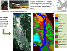
Estuaries and coasts are among the most productive ecosystems and constitute valuable habitats for biodiversity and ecosystem services. Amongst nearshore ecosystems, seagrass beds play a major role enhancing biodiversity and water quality. Consequently, the development of new approaches to create extensive and high resolution habitat maps is required not only to implement conservation, restoration and management plans, but also to establish adaptation plans to face climate change impacts. This study particularly assesses the capability of hyperspectral airborne imagery acquired with Compact Airborne Spectrographic Imager to discriminate and map estuarine habitats, with special focus on Zostera noltii seagrass meadows
Type